Monitoring Inventory

This Monitoring Inventory comprises information on existing monitoring efforts in the Northeast region. If you have a monitoring activity that you would like to add to the Inventory, please email Jackie Motyka.

Note: the Inventory was last updated in November 2020. If you are aware of a project that is missing, please contact us.  

How to navigate the Monitoring Inventory

These are the basic elements you can interact with on the Inventory’s map:

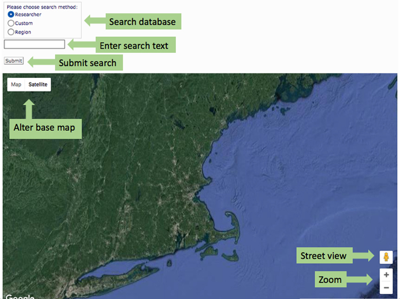
Accessing database information (records) requires the use of the search tool. There are three components to the search tool.

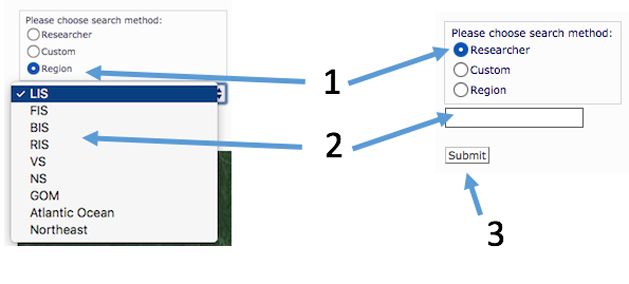
Choose a search method (1) – select a radio button (Researcher, Custom or Region). Selecting Region generates a drop-down list. LIS: Long Island Sound; FIS: Narragansett Bay area; BIS: Block Island; RIS: Rhode Island Sound; VS = none; NS: Southern Massachusetts; GOM = Gulf of Maine

(2). Selecting Research or Custom requires the entering of a word, name, or phrase. To complete the search, click the submit button (3).

The following image shows the results of a search. Locations are displayed on the map as either yellow or red pins. Yellow signifies all data for that record were collected at that location; red signifies that data for that record were collected from multiple locations, and the location of the pin is not representative of all of them. This approach was chosen to reduce map clutter. However, widely spaced stations such as NOAA tide stations each reflect an individual station. Click on a pin and a pop-up is displayed with the Program Name/Description. Click on the link in the pop-up, and the detailed record will display below the map.

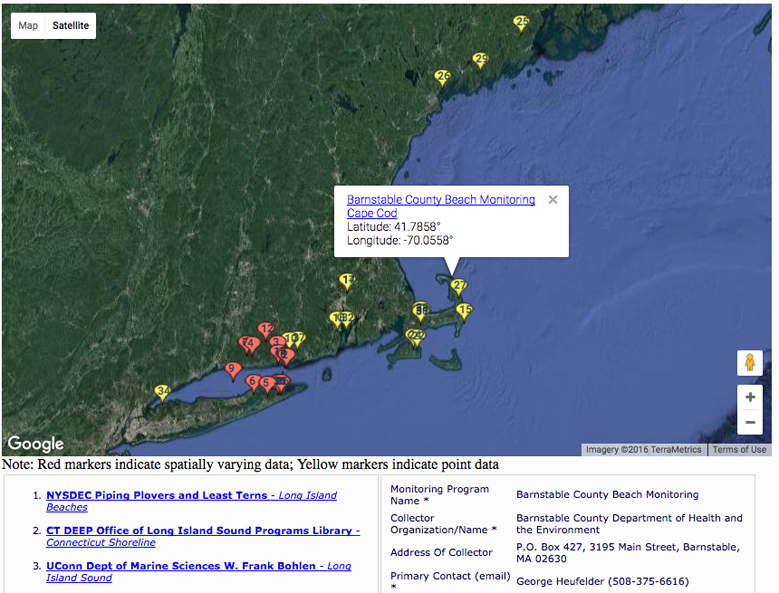
When a search is executed, a list of records is displayed below the map which contains the Program Names/Descriptions in the left column. The numbers correspond with the numbers on the map. Click on a link in the list in the left column, and the record will display in the right column. 

A record returns the following information:

  • Monitoring Program Name
  • Collector Organization/Name
  • Address of Collector
  • Primary and Secondary Contacts
  • State or Province
  • Primary and Secondary Waterbody
  • Ecoregion
  • Latitude and Longitude – reported in decimal degrees
  • Monitoring Location Description
  • Habitat Type(s) and Quality
  • Monitoring Objective
  • Parameters Measured
  • Climate Change Indicator (Is a climate change indicator monitored?)
  • Site Selection Method
  • Data Collection Equipment
  • Start and End of Data Collection
  • Collection Dates and Frequency
  • Data Format (digital or hard copy)
  • Digital Data Format
  • Spatial Data – yes (Data are collected for multiple locations) or no (Data come from a single sampling location)
  • Website
  • Metadata File (Is a metadata file available?)
  • QA/QC (Is there a quality control protocol?)
  • Data Distribution Policy (Is data public/open access?)
  • Citations
  • Documents
  • Comments
  • Sentinel – these are indicators and core parameters identified in the Strategic Plan.
  • Historic Data
  • Managed Areas
  • Partnerships
  • Regional Observation Networking
  • Synthesis
  • Long-term Monitoring

(Please note that the Monitoring Inventory may not properly display on mobile devices; we recommend viewing this page on a tablet or laptop)